Open House to the Public
April 26 through April 28, 2022
For the Lower Columbia River Federal Navigation Channel Maintenance Plan Dredge Material Management Plan
The U.S. Army Corps of Engineers (Corps) and the Columbia River non-federal Sponsors Ports (Longview, Kalama, Woodland, Vancouver, and Portland) are hosting five information sessions to update the public on the Lower Columbia River Channel Maintenance Plan (LCR CMP) Dredge Material Management Plan (DMMP). Corps policy requires all federally maintained navigation projects demonstrate there is sufficient dredged material placement capacity for a minimum of 20 years.
Joint and Lead Agencies: To satisfy requirements of NEPA and SEPA, the Corps and Sponsor Ports will jointly prepare an EIS on the Plan. The Corps is the lead agency under the National Environmental Policy Act (NEPA). The Sponsor Ports are cooperating agencies under NEPA. In addition, the Washington Ports are co-lead agencies under the State Environmental Policy Act (SEPA) with the Port of Longview serving as the SEPA nominal lead agency.
In 2017, interested parties and tribes were notified that the Portland District of the Corps and the Sponsor Ports are preparing a joint Environmental Impact Statement (EIS) for The Lower Columbia River Federal Navigation Channel Maintenance Plan (82 FR 42548). An extended scoping period was provided from September 8 through November 16, 2017, per NEPA (40 CFR 1501.7) and SEPA (RCW 43.21C.030(2)(c)). Public participation informs the NEPA and SEPA environmental review process. The Scoping Report is posted on the Corps’ website.
Public Open House: A series of public open house meetings are scheduled for April 2022. The dates, times, and locations of the meetings are listed below. The public open house will provide an update on development of the LCR CMP DMMP and EIS. The open house is meant to:
- Update the public: Corps’ planning process for the LCR CMP DMMP
- Outline next steps: Schedule of release of the Draft LCR CMP DMMP and EIS for public review and comment
- Provide a facilitated session of questions and feedback
All meetings will be conducted virtually through WebEx. All open houses will present the same content. Several options are presented to provide flexibility to the public.
- Tuesday, April 26, 2022 from 1-2:15 p.m.
- Wednesday, April 27, 2022 from 1-2:15 p.m.
- Wednesday, April 27, 2022 from 6:30-7:45 p.m.
- Thursday, April 28, 2022 from 1-2:15 p.m.
- Thursday, April 28, 2022 from 6:30-7:45 p.m.
If you wish to join only by phone, you will not be able to see the presentation but will be able to listen. The phone-only call-in number Is the same for all meetings:
U.S. Toll Free 1-877-309-3457
U.S. Toll 1-404-397-1516
Use the access code/event number listed in the table above to join by phone.
Public Involvement: The Corps and Sponsor Ports invite all affected Federal, state, and local agencies, affected Native American Tribes, and other interested parties to participate in the public open houses. The purpose of the public open houses is to provide information to the public on the Corps’ process and to explain what can be expected in the future for release of the Draft LCR CMP DMMP and EIS. The specific dates, times, of the meetings are provided above. All meetings will be conducted over WebEx.
For additional information on the EIS process, the Corps and Sponsor Ports recommend referring to the guidance provided in “The Citizens Guide to NEPA” available at the following link: https://ceq.doe.gov/get-involved/citizens_guide_to_nepa.html.
For More Information: Please visit the website http://www.nwp.usace.army.mil/lcrchannelmaintenance/ or contact the Corps at the project mailbox: ColumbiaNavChannel@usace.army.mil
SEPA Responsible Official:
Lisa Hendriksen, Port of Longview
NEPA Specialist:
Omar Ortiz, U.S. Army Corps of Engineers, Portland District
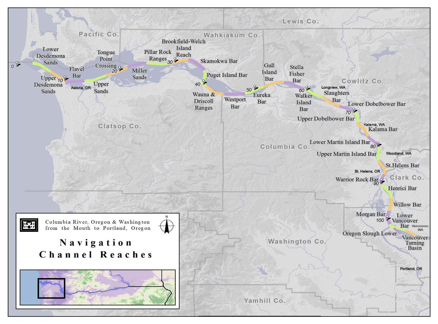
Project Description and Location: The Lower Columbia River Federal Navigation Channel project includes a main channel that is 43 feet deep and generally 600 feet wide, and extends upstream of the Mouth of Columbia River, River Mile (RM) 3 to Vancouver, WA, RM 105.5. The channel also extends into Lower Oregon Slough and includes vessel turning basins at Astoria in Oregon and Longview, Kalama, and Vancouver in Washington. The channel is maintained using a combination of dredging and hydraulic control works (pile dikes). Advanced maintenance dredging is currently approved up to 5 feet below authorized depth (-48 feet) and up to 100 feet outside the authorized channel width. For the past several years, dredging 6 to 8 million cubic yards of localized sand shoals has been required annually to provide reliable service for deep-draft navigation.
The Corps’ policy requires all federally maintained navigation projects to demonstrate that there is sufficient dredged material placement capacity for a minimum of 20 years. The Plan is intended to ensure warranted and environmentally acceptable maintenance of the 43-foot Lower Columbia River Federal Navigation Channel for the next 20 years. Specifically, the Plan will be designed to facilitate efficient management of dredged material, accounting for variability of shoaling processes, to provide a reliable channel for deep- draft navigation. The Plan will describe the results of investigations and analyses used to make determinations as to current and forecasted dredging needs and material placement capacity, potential additional placement sites, measures to reduce the need to dredge and avoidance, minimization, and mitigation measures as needed.