Dams and reservoirs

Congress originally authorized the construction of 15 dams in Portland District to reduce the risk and damages from flooding. While flood damage reduction remains the dams’ highest priority authorization, Congress also authorized the Corps to store and release water from these projects for additional uses, such as irrigation, municipal and industrial uses, water quality, fish and wildlife enhancement and recreation. To learn how most of these dams manage water, watch this video.

Mid-Columbia River projects

Color relief map of the Columbia River Gorge and surrounding area

The Corps owns and operates three dams on the Mid-Columbia River Basin: John Day, The Dalles and Bonneville. Congress originally authorized the construction of these basin projects primarily for hydropower generation and navigation. John Day Dam creates a relatively small amount of storage in Lake Umatilla to help manage river levels on the lower Columbia during major floods.

Mt. St. Helens Sediment Retention Structure

The Corps owns and operates the Sediment Retention Structure on the Toutle River in southwest Washington. Congress authorized this project after the 1980 eruption of Mount. St. Helens to trap sediment entering the Cowlitz and Columbia rivers. This sediment could potentially increase flooding by reducing river flow capacity and disrupt navigation. The SRS does not store flood water, only sediment.

Rogue River Basin Project

Map showing Rogue River Basin locations

The majority of the flood storage space in southern Oregon’s Rogue River Basin is available from two Corps storage projects. Applegate Dam and Reservoir controls about 29 percent of the Applegate River Basin. William Jess Dam and Lost Creek Reservoir controls about 28 percent of the Rogue River’s drainage area and about 50 percent of the average annual runoff at Grants Pass.

During the wettest time of the year (mid-November through January) and during significant rain events, the Corps stores water flowing into the reservoirs. As water levels in uncontrolled rivers in the watershed subside, the Corps releases the water. River levels may remain high for an extended time after rain events as stored water is released. Whenever possible, the Corps tries to keep river levels at or below the “bankfull” levels established by the National Weather Service.

These two projects also support irrigation, recreation, fish and wildlife habitat enhancement and water quality improvement. Lost Creek Reservoir also stores water for municipal and industrial water supply use.

Willamette River Basin

Map of the Willamette Valley Project

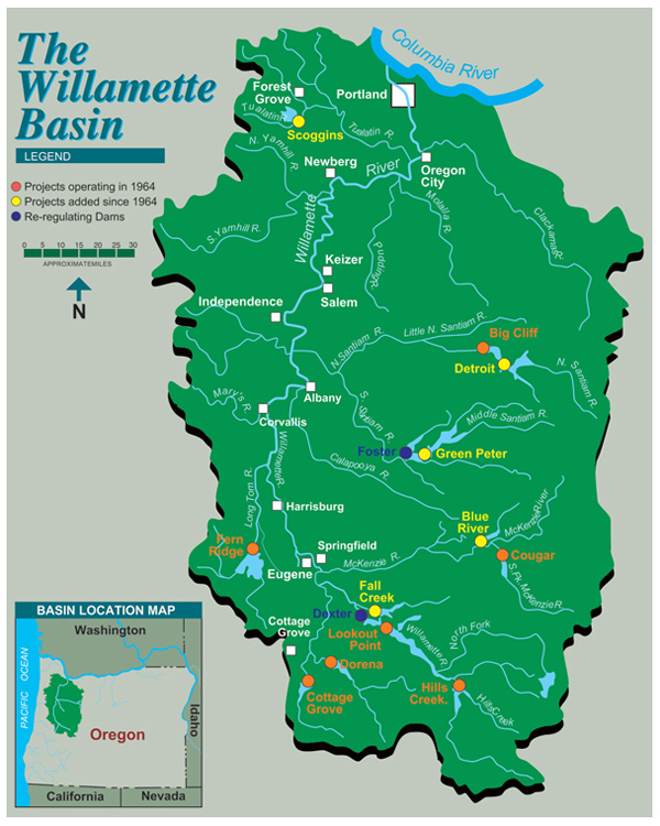
The Corps owns and operates 11 dams (with two re-regulating dams) and storage reservoir projects in the Willamette River Basin to help reduce flooding downstream as far north as Portland, Ore. The majority of the flood storage space in the larger basin is available from these reservoirs in the North and South Santiam, McKenzie, and Coast and Middle Fork Willamette river basins.

During the wettest time of the year (mid-November through January) and during significant rain events, the Corps stores water flowing in the reservoirs. As water levels in uncontrolled rivers in the watershed subside, the Corps releases the water. River levels may remain high for an extended time after rain events as stored water is released. Whenever possible, the Corps tries to keep river levels at or below the “bankfull” levels established by the National Weather Service.

Big Cliff and Dexter dams are used to regulate, or even out, the vacillating flows from power-generating operations at the much larger Detroit and Lookout Point dams, respectively. While built under the same Congressional authorizations as the other dams, they are not operated to reduce flood risks.

The U.S. Bureau of Reclamation can be operate its Scoggins Dam in the Tualatin River Basin to provide additional water storage to further reduce localized flood risks.

It is a carefully monitored system. Operators releasing water from the dams in the southern part of the valley must take into account all the uncontrolled water flowing into the system to the north. The dams can manage about 77 percent of the water flowing into the drainage area above the Eugene-Springfield area. At Albany, only about 43 percent is manageable. In Salem, that drops to 42 percent. And in Portland, only about 27 percent of the drainage area above is managed.

Willow Creek Dam

Willow Creek Dam from downstream

The Corps owns and operates the Willow Creek Dam and Reservoir project in the town of Heppner, Ore., about 45 miles south of Hermiston, Ore. The use of this reservoir is unique to Portland District water storage projects in that the largest flood events in the Willow Creek basin are flash floods caused by thunderstorm activity, typically in the summer. Willow Creek Dam controls about 65 percent of the Willow Creek watershed and about 65 percent of the average annual runoff at Morgan Street in Heppner.‎ Stored water supports downstream water supply and irrigation uses.

Reservoir teacup diagrams

Visit river basin “teacup” diagrams for real-time reservoir levels. Each project’s smaller “teacup” includes observed inflow, precipitation levels and its specific rule curve. The diagrams also show releases from dams for the past seven and 30 days: