Off the coast of Oregon, Big Bertha moves in the water, inching toward land.
Bertha, as her government creators to refer to it, is the result of three years of inter-agency planning.
Her architects; some of whom work for the Portland District, U.S. Army Corps of Engineers; conscripted half of Portland District’s dredge fleet to scrape the river bottom and collect what was to become Bertha: a migrating mound of sand.
Rod Moritz is a hydraulic engineer and project manager with Portland District, and has overseen the sediment project/pilot study.
“In this case, Bertha is a new life for Peacock Spit and Benson Beach,” said Moritz.
Peacock Spit and Benson Beach lie near the Mouth of the Columbia River, which is also known as the Pacific’s Graveyard for one reason: the explosive kinetic energy of the river as it collides with powerful ocean currents births some the most devastating waves mariners have ever experienced. Both the spit and beach are named for ships that wrecked in the area.
Those same merciless waves shorten nearby beaches through erosion. According to the National Oceanic and Atmospheric Administration, in the United States, coastal erosion is responsible for roughly $500 million per year in coastal property loss, including damage to structures and loss of land.
Areas like Benson Beach need the sandy shorelines to absorb the power of ocean waves, reducing them to a gentle wash of water across the beach.
Enter the Portland District, which operates dredges that are in the business of slurping up sand and sediment from federally navigable river bottoms (ensuring safe passage for vessels) and then burping that sand out into pre-determined and vetted locations elsewhere.
That “elsewhere” is a location that has been approved and vetted through an extensive inter-agency regulatory process that is too dull and too off-topic to explain here, but is explained HERE.
The placement area for Benson Beach and Peacock Spit is known as the North Head site.
There, the nearshore mound was masterfully laid on the ocean floor – trickling out the bottom of the dredge Essayons, which had to maintain straight-line courses and perfect sediment placement near those deadly waters. If the vessel goes too fast, and they won’t complete the load dump by the end of the run. Go too slow and the sediment placement builds up, negating the “thin-layer placement” the team needed to achieve.

Above: The dredge vessel Essayons

Above: Plume dynamics of underwater sediment placement
The pilot program’s sand placement happened in three phases, starting in 2018 when the Essayons dredged the Columbia River and shuttled it to the North Head site, forming a long mound of sand that was about one football field wide, 20 football fields long and about 2 feet deep.

Above: Phase I dredged material placement area
The placement was considered successful after determining that the mound would indeed disperse at the North Head site.
But tracking the sediment movement, needed to determine whether the sand was moving toward the beach it was meant to renourish, was more complicated.
“Tracking sediment movement is like trying to track smoke,” said Moritz. “The environment is so energetic that we couldn’t see where it dispersed, and we knew we needed more information.”
For the second phase of the program, the team wanted to track the results of the sediment movement if the dredged material was laid in different directions. Sediment movement can be affected based on a sand mound’s orientation with respect to the shore or the approaching wave angle, according to Moritz.
The resulting new task for the Essayons was creating two long berms of sand perpendicular to each other, which would look like a “T” in the water.
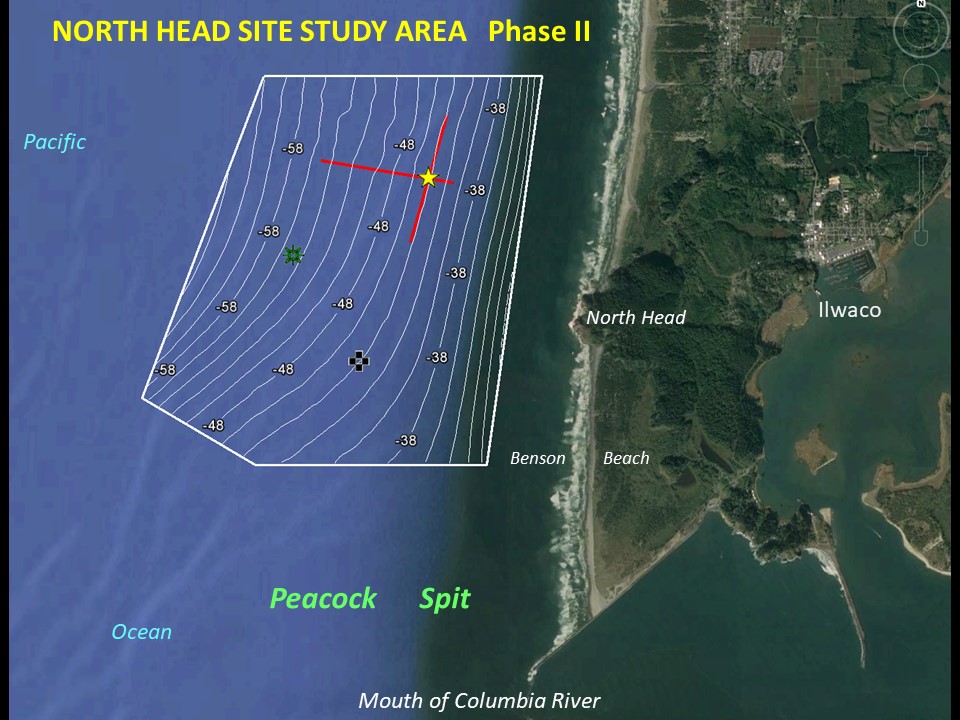
Above: Phase II dredged sediment placement area
To do this, the Essayons (and a smaller hydrological survey vessel, “Elton”) had to travel abreast of the waves, or parallel to the shore.
NOTE: There’s one thing any good vessel captain or commander knows, it’s that it is best to travel into the waves, letting them slap the front hull of the vessel. Or, the alternative: allow the waves to break over the rear of the boat. It is least desirable to be caught with the waves coming at you from the side, or “abreast” of the waves. The wave movement tosses the crew, any loose item, and whatever’s cooking in the galley about the vessel like shake-and-bake chicken. It can be deadly, and captains actively avoid this orientation in the water.
Troy Erzberger is the assistant master of the Dredge Essayons and was onboard for the pilot project sediment placement.
“You spend your whole career trying not to travel abreast of the waves because it places the ship in a precarious position: you have limited control of the vessel while trying to perform a ‘controlled dump’ of sediment,” said Erzberger.
But the crew stomached the extreme conditions as the dredge artfully spat out 100,000 cubic yards of sediment in the turbulent waters:
“On the bridge there are moments of utter chaos when charts, plotting tool, miscellaneous paperwork and the forgotten mug of coffee or other such beverages takes flight, spilling contents and begin to pinball around the deck,” said Erzberger. “(This is) usually followed a by a few choice words.”
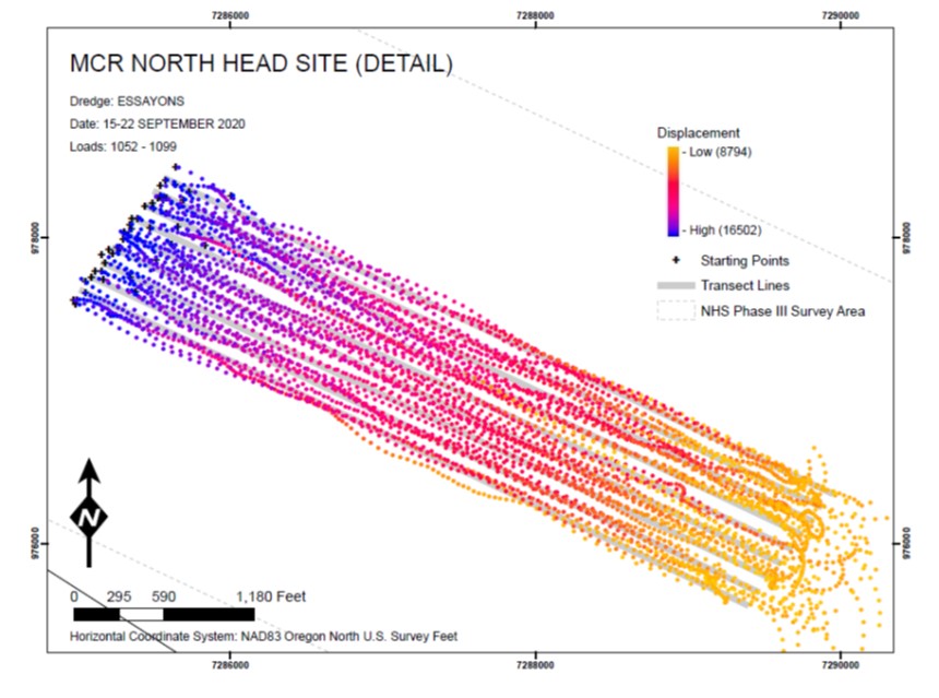
Later, the nimble survey vessel, Elton, repeated the same track as Essayons over the following months, beaming its multibeam sonar into the turbid depths, mapping the curves of the new mound.

Above: The survey vessel Elton
The team gathered and reviewed all the information– aerial photos, maps of the berm teams, ocean current information and more – and began to plan the final third phase: Big Bertha.
The Essayons began the task of the thin-layer placement that would build Bertha in late 2020. To the great comfort of the Dredge Essayons crews, the along-shore placement was not necessary this time: the team discovered the mound orientation in the water did not affect placement. The Essayons lugged 47 loads of dredged material from the Columbia River (and made 47 trips) to the North Head site, placing a total of 283,000 cubic yards of sand.

Above: The path the Essayons took between the dredge site and the placement site is highlighted in yellow.
Above: The Essayons made long runs down a pre-determined path to place dredged material.
Moritz emphasized that while placing dredge material can seem a small measure compared to the amount of sediment the ocean churns, the project’s success lies in the incremental progress that can be adjusted to reduce coastal erosion.
When the Essayon tapped out after delivering their sandy payload, the team sent the crew of the survey vessel Elton to look for a signature of material, or a “tell,” of being moving away from the mound.
“We’re looking for something that looks like snow drifts,” said Mortiz. “We color-code the contours to track the elevation changes as the mound migrates toward shore.”
In April, the team delivered the most recent survey results on Bertha’s movement: Bertha was migrating toward Benson Beach.
Based on their projections, sand from Bertha is already sunning itself on the beach, right on time for summer. It’s also in time to celebrate a milestone, as the North Head site “graduates” from pilot program status: the site will regularly receive dredged material, beginning later this summer when the Essayons delivers 400,000 cubic yards of sand.