Learn how Willamette Valley reservoir levels may be impacted by court-ordered measures.

Contact us about Cougar:
General: 541-684-4300
Recreation: 541-942-5631

Email us about Cougar

Cougar pamphlet

Cougar Dam & Reservoir

Cougar Dam

Project Description
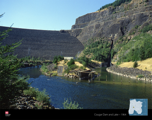
Cougar Dam is located on the South Fork McKenzie River 42 miles upstream of Eugene and Springfield, Oregon. Cougar Dam is a 519 ft tall, 1,600 ft long rockfill earthen embankment dam with a concrete spillway, two spillway gates, an intake structure with regulating outlet, and a powerhouse. Cougar Dam is owned, operated, and maintained by the Portland District of the U.S. Army Corps of Engineers (USACE). Construction of the dam began in 1959 and was completed in 1963. Cougar Dam is part of a system of 13 multi-purpose dams in the Willamette Valley with the primary purpose of flood risk management and secondary purposes of hydropower, recreation, irrigation, municipal and industrial water supply, fish and wildlife, and water quality. Collectively, this system of dams is referred to as the Willamette Valley Project.

During the winter months, the Willamette Valley Project reservoirs are maintained at low elevations to allow for the temporary storage of rain and snow melt. When managing high flow events, the outflow from the system of dams is coordinated to reduce peak flows and river stages at downstream locations. In spring, USACE begins to refill the reservoirs, increasing the amount stored for conservation purposes and reducing the amount available for flood risk management.  During summer, stored water is used for recreation on the reservoirs, and some stored water is released in the river downstream to improve water quality, produce hydropower, support fish and wildlife habitat, and provide water for irrigation and municipal uses. During dry summer months, flows into the reservoirs are generally less than flows needed to meet minimum flow objectives, causing reservoir levels to drop. In fall, stored water remaining in the reservoir is drawn down to minimum levels in preparation for the flood season.
Cougar Dam is located about 100 miles east of the Cascadia Subduction Zone, a megathrust fault along the Oregon Coast. The Cascadia Subduction Zone is capable of producing very large, long duration earthquakes. The last Cascadia Subduction Zone earthquake occurred in the year 1700.   

Risk Characterization: High
USACE performs risk assessments as part of an ongoing dam safety program and to assist in the prioritization of investment for aging infrastructure.  The risk assessments evaluate the life safety risks associated with the dams to determine if risk reduction actions are needed and, if so, what actions should be taken.  USACE has been conducting advanced risk assessments, called Issue Evaluation Studies (IES), at several Willamette Valley Project dams including Cougar Dam.  
The assessment considers a wide range of hazard scenarios from the most likely to the most extreme and unlikely.  As of June 2020, results of the advanced study for Cougar Dam identified the risk associated with the dam to be High. The risk is driven by the large population downstream combined with the potential for an extreme earthquake occurring at the same time reservoir elevations are the highest.  According to the study, a large earthquake could cause the rockfill earthen dam to settle, resulting in water overtopping the dam. It is difficult to predict the exact amount of settlement that could occur to the dam as a result of such an earthquake. The speed and depth of water overtopping a damaged dam could erode the soil and rock that forms the dam and cause significant flooding downstream.  The shaking from an earthquake could also open up cracks through the rockfill earthen dam, allowing water to flow through the dam. The force and speed of the flowing water through the cracks could cause the dam to be further damaged by eroding away the embankment material, resulting in uncontrolled release of water from the reservoir, and flooding areas downstream.  Because Cougar Dam is located upstream of Eugene and Springfield, Oregon, there is potential for devastating flooding to affect large downstream populations in urban areas and surrounding suburbs, as well as rural communities in the floodplain and narrow canyons.

USACE is confident that the Willamette Valley dams are well-built, well-maintained, and will continue to significantly reduce flood risks for the region. However, the dams cannot eliminate potential for flooding. Even with the presence of the Willamette Valley dams, extreme rainfall and snowmelt events may result in flooding in areas downstream of dams.  Flooding can be caused by high flows resulting from unregulated portions of the watershed and/or high flow that must be passed through the dam outlets and spillways when reservoir storage capacities are exceeded. 

Risk Management Measures
The likelihood is low for an extreme earthquake to occur, but the potential impacts of a dam failure are very high due to the large downstream population. USACE continues to evaluate the seismic performance of the embankment to determine if short-term targeted measures (called Interim Risk Reduction Measures), or long-term modifications will be necessary to reduce risk.  USACE regularly conducts routine inspections of its dams and Cougar Dam is equipped with instrumentation to monitor dam performance and seismic activity. Post-earthquake procedures are in place to inspect and evaluate earthquake damages and USACE conducts routine dam safety exercises with local Emergency Managers and first responders. Cougar Dam’s Emergency Action Plan (EAP) outlines actions to be taken during an emergency. USACE will update the EAP based on recent risk assessment results and information from updated inundation maps. In addition, USACE will continue and increase its outreach to improve community awareness of flood risks and risks associated with the dam. 

View more details about Cougar Dam at the National Inventory of Dams website.

Cougar recreation

Birding: The project encompasses almost 5,000 acres and the uplands are managed primarily through an agreement with the Willamette National Forest. The reservoir is a designated stop along the Three Sisters section of the Oregon Cascades Birding Trail. This Trail is a self-guided auto tour of nearly 200 prime birding destinations in the Oregon Cascades. American peregrine falcons have been observed around the cliffs above the lake.

Camping and day-use parks: Recreation facilities at Cougar are operated by the U.S. Forest Service. Call the McKenzie River Ranger office at 541-882-3381 or click one of the links for more information: Echo day-use area; Slide Creek Campground; Sunnyside Campground; French Pete Campground; or Delta Campground.


Environmental stewardship at Cougar Dam

The project encompasses almost 5,000 acres and the uplands are managed primarily through an agreement with the Willamette National Forest. To mitigate impacts of Corps dams on Chinook salmon and resident fisheries within the McKenzie River basin, the Corps built the McKenzie Hatchery. The Oregon Department of Fish and Wildlife maintains and operates the hatchery with funds from the Corps of Engineers and the State of Oregon.

In 2004, the Corps completed a temperature control tower for Cougar Dam, which improved downstream conditions for threatened fish species. Currently, the Corps is operating a new fish ladder and holding facility below the dam that allows biologists to collect adult fish from the river and transport them upstream to their natal streams.  The Corps also promotes resident fisheries throughout the McKenzie River basin through the continued support of Leaburg Hatchery and as a partner in efforts to recover bull trout and Oregon chub within the McKenzie River drainage.

Cougar Adult Fish Collection Facility

aerial view of the adult fish collection facilityBiologists estimate the habitat above the dam once supported more than 4,000 returning adult spring Chinook. Original construction included both adult and juvenile fish passage facilities to help move fish past the dam. However, due to the dam’s impact on downstream river temperatures, adult fish no longer migrated to its base. The Corps abandoned the original adult and juvenile fish passage facilities because they proved to be ineffective.

In combination with the Cougar Dam Temperature Control Tower, this new $10.4 million collection facility supports a complete fish life-cycle over long stretches of the South Fork McKenzie River by moving adult fish to high quality spawning habitat above the dam. Fisheries biologists believe this will substantially support recovery of endangered fish populations in this Willamette River sub-basin.

The facility includes a fish ladder leading from the base of the dam to a fish collection and sorting area. From there, adult salmon, bull trout and other resident fish are loaded onto trucks and transported to release locations above Cougar Reservoir. The facility’s design incorporates the best features of trapping facilities at other locations, including Bonneville Dam and the Cowlitz River in southern Washington.

The Corps operates and maintains the facility according to guidelines developed collaboratively between the Corps, Oregon Department of Fish and Wildlife and other agencies. ODFW determines which fish species, and how many, are moved above the dam for natural spawning. ODFW biologists are on site daily conducting research and monitoring during operational months of May through October, when spring Chinook enter the South Fork McKenzie River.

Returns of wild adult spring Chinook salmon to the trap since it opened in 2010 have ranged between 250 and 525. We expect similar returns in the future until a long-term solution is implemented to help improve survival of juvenile salmon attempting to pass the dam on their way downstream from their spawning grounds to the ocean.

Cougar Temperature Control Tower

The Corps modified the dam’s intake tower by adding adjustable weir gates and a wet well. The new features allow dam operators to selectively draw water from various depths of the reservoir and mix it to a temperature more closely matching pre-dam downriver conditions.

Total cost of the project from pre-construction work in 1999 to completion in 2005 was $50.5 million. The first phase of the construction began in June 2000 when the diversion tunnel used to redirect the river during initial dam construction was excavated, reinforced and gated. The diversion tunnel was opened in April 2003, drawing the reservoir down to about one-third its normal size to allow the south face of the intake tower to be fitted with its new wet well and adjustable weir gates.

Total cost of the project from preconstruction work in 1999 to completion in 2005 was $50.5 million. The first phase of the construction began in June 2000 when the diversion tunnel used to redirect the river during initial dam construction was excavated, reinforced and gated. The diversion tunnel was opened in April 2003, drawing the reservoir down to about one-third its normal size to allow the south face of the intake tower to be fitted with its new wet well and adjustable weir gates.

There are three vertical slots running almost the full length of the face of the wet well, each with a set of three overlapping weir gates. Since water temperature within a reservoir changes with increasing depth, the gates can slide up and down as needed to create openings at various levels in the lake. Water drawn in through the openings is mixed to the proper temperature in the wet well and then routed through the penstock to the powerhouse or regulating outlet downriver.

Wild adult spring Chinook salmon began returning to the South Fork McKenzie River almost as soon as the temperature control tower came on line. Returns to the new adult fish collection facility downriver of the dam since it opened in 2010 have ranged between 250 and 525. We expect similar returns in the future until a long-term solution is implemented to help improve survival of juvenile salmon attempting to pass the dam on their way downstream from their spawning grounds to the ocean.

Cougar Portable Floating Fish Collector

The dam’s temperature control tower helps closely mimic pre-dam downstream water temperatures, but poses serious challenges for endangered juvenile spring Chinook salmon trying to migrate out to sea. All water passing Cougar Dam must flow though the tower, but flow conditions at the corner of the reservoir where the tower is located make it hard for fish to find and enter it. Passage efficiency and survival rates of those that do manage to enter the tower are not high enough to support a self-sustaining wild Chinook population.

Drawing of the Cougar Dam Portable Floating Fish CollectorDrawing of Cougar Dam Portable Floating Fish Collector

The project delivery team working on downstream passage options at Cougar Dam identified the most likely solution as a surface collector that attracts and holds juvenile Chinook until they can be transported around the dam. However, the team realized that there were too many data gaps to make an informed decision about design.

The portable floating fish collector is a small-scale experimental fish collector to help inform the decision-making and design of a future permanent downstream passage solution.

The PFFC is a large pump-driven intake and collection structure surrounded on three sides by a floating hull moored vertically to the reservoir bottom in four places, and anchored horizontally by cables extending to the dam face and adjacent hills. The collector’s pumps generate an attraction flow of about 100 cubic feet per second.

It is equipped with a PIT tag detector and other equipment to help determine how efficient it is at collecting fish. The PFFC will also provide valuable information about the operations and maintenance requirements for whatever permanent solution is ultimately decided upon – debris loading, maintaining moorage in a fluctuating reservoir, daily boarding and operations, etc.

A few utilities use large-scale collectors as permanent fish passage solutions, but only at reservoirs that fluctuate up to about 50 feet. No small-scale collector built to stand a 180-foot reservoir fluctuation like Cougar’s then existed.

The Corps contracted engineering firm HDR and naval architects at Art Anderson Associates to design the PFFC. Cherokee Construction Services built and assembled it.

Getting around


Flood risk management at Cougar Dam

Conservation season - April to November: None.
Flood season - November to March: Replace wire ropes and restrict pool to 1671 feet.

For more information, visit our Water page.