Parking Information

For security reasons, the parking area adjacent to the Project Office will be gated closed each day at 5:15 p.m.
It will reopen each morning at 5:15 a.m. Additionally, the front door to the Project Office will remain locked during the day -- knock and Corps staff will assist you. Please plan your visit accordingly.

Lost Lake project data

Dam length 3,750 ft 1,143 m
Height 327 ft 100 m
Elevation (NGVD*) 1,882 ft 570 m
Max. capacity 2 generators 49.2 mw
Lake length 10 mi 16 km
Lake area (full) 3,430 ac 1,389 ha
*National Geodetic Vertical Datum
(Mean Sea Level)

Contact us about Lost Creek:

Phone: 541-878-2255

Email us about Lost Creek

Reservoir elevation, flow and temperature report: 800-472-2434

Lost Creek Lake is on the Rogue River, about 28 northeast of Medford, Oregon.

Jess Dam and Lost Creek Reservoir

William L. Jess Dam is situated on the main stem of the Rogue River, about 28 miles northeast of Medford, Ore., in a timbered canyon on the Rogue River. The Lost Creek Reservoir and features public access areas, parks, boat ramps and 30 miles of scenic trails.

Jess Dam at Lost Creek is a 327-foot-high rockfill embankment structure with a gated spillway. Jess Dam was the first of three multi-purpose storage projects finished in the Rogue River Basin project. 

Authorized primary purposes include flood risk management, water supply, water quality improvement, fish and wildlife habitat enhancement and recreation.

In 1996, Congress renamed Lost Creek Dam in honor of William L. Jess, a strong advocate for multiple uses of impounded waters and one of the founders of the Rogue Basin Association, established in 1955.

Link to PDF version of Lost Creek map

Jess Dam Operations

Lost Creek / William L. Jess Dam and Reservoir

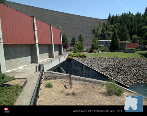
The William L. Jess Dam and intake structure is a 327-foot-high rockfill embankment structure. Construction began in 1967 and the lake began filling in February 1977. Runoff from a drainage area of 674 square miles pools into Lost Creek Lake. The lake provides 465,000 acre-feet of total storage and has an area of 3,430 acres when full.

A regulating outlet tunnel, power penstock, and intake tower with multi-level intakes are located in the dam's right abutment; a gate-controlled concrete chute spillway is located in the left abutment. The powerhouse's generating capacity of 49,200 kilowatts comes from two 24.6-megawatt generators.

Environmental concerns prompted the Corps to construct an innovative multi-port intake tower, allowing operators regulate the temperatures of water released from the lake. Lost Creek’s intake structure combines lake water from different depths in a mixing chamber before releasing it downstream, regulating the water temperature and improving conditions for fish migration and survival in the Applegate and Rogue rivers. 

The returning fish are collected just below the dam and transported to the Cole M. Rivers Fish Hatchery, located just downstream of William L. Jess Dam on the Rogue River, for spawning. Later, juveniles are released into the Applegate River to maintain the runs.

For the reservoir elevation, flow and temperature report, call 800-472-2434.

Boating at Lost Creek Lake