1. Project Name and Status
a. Project Name: Charleston Marina Navigation
b. Project Status: Tentatively Selected Plan Milestone scheduled for Q4 FY 24
2. Corps District and Sponsor
a. Corps District: Portland District
b. Corps Sponsor: Port of Coos Bay
3. Congressional Delegation: The study area is in Oregon’s 4th Congressional District represented by:
- Representative Val Hoyle (D)
- Senator Ron Wyden (D)
- Senator Jeff Merkley (D)
4. Location: The study area includes the Coos Bay Estuary located in Coos County (Figure 1). The estuary is approximately 13,000 acres in area and has a watershed of approximately 1058 sq mi. This estuary is designated for deep draft development and includes the 15-mile Coos Bay FNC and the 1-mile Charleston FNC. The Corps also owns and maintains multiple navigation features within the study area including the North and South Jetties where the Coos River enters the Pacific Ocean.
The Port of Coos Bay, which includes multiple sites in the estuary, is the largest coastal harbor by volume in Oregon handling more than 1.5 million tons of cargo annually.
The Charleston Marina Complex is located on the South Slough of the Coos Bay Estuary at the south end of the Charleston FNC. The Charleston Marina provides moorage for 165 to 200 commercial fishing boats and has an additional 250 recreational boat slips. The marina has a six-lane boat ramp and several offloading facilities for commercial fish processing, and a commercial ice plant. The boat basin includes the U.S. Coast Guard (USCG) Lifeboat Station and aids to navigation team, the University of Oregon’s Oregon Institute of Marine Biology, fish offloading and processing facilities, the only commercial fuel point in Coos Bay, and the Charleston Marine Life Center.
5. Alternative Plans Considered: The Future Without Project was considered in addition to the preliminary array of alternatives that included establishment of an access channel, modifications to the Charleston Breakwater, sediment catchment basins, material removal around the breakwater, modifications to in water disposal sites, and beneficial use of dredge materials. During alternatives development of the feasibility phase, the project delivery team will formulate a focused array of alternatives to be evaluated along with the Future Without Project Condition (No Action Alternative).
The Future Without Project conditions include no improvements to the Charleston Marina Complex entrance channel and no construction. In the past, the sponsor has dredged the area, but the resources for continued dredging are limited and the sponsor is seeking assistance from USACE. Absent such improvements, the consequence is a continuation of unsafe maneuvering space at the north marina entrance for larger commercial vessels during low tide and unsafe conditions that could lead to more vessel groundings (Figure 2). This will mean continued tow assistance, continuation of current operations to assist immobilized and space restricted vessels, and the fuel dock can only fuel vessels during high water. Federal interest exists to maintain the existing Charleston FNC which provides access to multiple beneficiaries including commercial seafood processing facilities, a boatyard, US Coast Guard Station, and the bulk of the commercial and recreational boat slips within the Charleston Marina. A more comprehensive solution to the shoaling at the North Entrance would ensure access to seafood processing facilities in the north marina, the Coos Bay OR Department of Fish and Wildlife station, and Russel’s Marine Fuel and Supply, public boat launch, in addition to improving safety and reliable access to the southern portion or the marina with similar commercial and recreational facilities. Since the shoal spans both the entrance channel and FNC, lack of a comprehensive solution will likely result in increased dredging costs and frequency for both the Port of Coos Bay and USACE as sediment shifts after either side is dredged.
6. Description of Likely Recommended Plan: The likely recommended plan may include extension of the Federal Navigation Channel, excavating of feeder shoals contributing to transportation inefficiencies, and/or modifications to the Charleston breakwater feature. Dredge disposal areas are also being assessed as part of plan evaluation and selection.
The likely recommended plan addresses the objectives developed for this study over a 50-year period of analysis:
Objective 1 – Reduce or eliminate inefficiencies due to tide, vessel, and loading restrictions caused by shoaling within the Charleston Marina north entrance.
Objective 2 – Improve safety conditions near the Charleston Breakwater by reducing congestion and decreasing the likelihood of grounding on shoals in or near the FNC.
Objective 3 – Maintain continual access to unloading and fueling facilities that are currently and have been previously impacted by shoaling.
The identified alternatives developed support the Federal objective of water and related land resources project planning is to contribute to national economic development consistent with projecting the Nation’s environment, pursuant to national environmental statutes, applicable executive orders, and other Federal planning requirements.
7. Schedule:
Execution of FCSA: June 2023
Tentatively Selected Plan: September 2024
Approval of Feasibility: July 2025
Initial Construction award (FY): FY26
8. Authorization, appropriations act, or report language: Section 107, River and Harbor Act of 1960 (PL 86-645), as amended for commercial navigation. This study was initiated by a request from the Port of Coos Bay who is the non-Federal Sponsor.
9. Project Maps:

Figure 1: Location of Charleston Marina Study Area
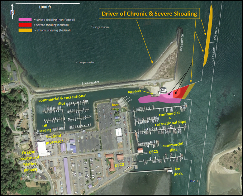
Figure 2. Charleston Marina with potential drivers of shoaling in the FNC and north marina entrance