Building Strong® at Wahkiakum Ferry Channel

Wahkiakum FerryThe Wahkiakum Ferry Channel is authorized to 9 feet deep and 200 feet wide, from the ferry berth at Puget Island, Wash., to deep water in the Columbia River. The project is located across from Westport Slough channel in Oregon.


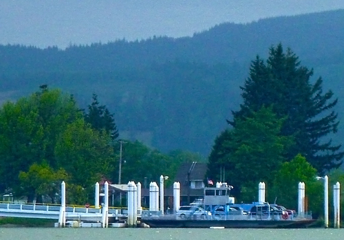
The navigation channel supports the Wahkiakum Ferry, which provides interstate transportation to the entire Lower Columbia region. The ferry runs between Cathlamet, Wash. and Westport, Ore., carrying more than 50,000 vehicles each year.


In addition to being the most energy efficient local travel option, it also provides a critical alternative route for interstate traffic when the nearest bridges (26 miles upstream or 43 miles downstream) or highways are closed by weather, traffic accidents, or other causes.


Wahkiakum County completed a $2.8 million ferry terminal upgrade investment in 2010, and plans to put a new, larger $3.9 million ferry vessel into service in 2014. Clatsop County plans $2.4 million in improvements to the ferry landing at Westport to accommodate the new ferry. Federal and state funds are contributing to these investments. The new ferry will have double the capacity for vehicles, and its larger deck will hold tour buses and trucks. Wahkiakum County has requested modifications to the authorized channel to support the new, larger ferry and ferry terminal upgrade.

For more information

Contact us:

Phone: 503-808-4510

Email us about the Wahkiakum Ferry channel

Latest News Releases

USACE invites public to Willamette Valley reservoir levels info session
5/23/2024
Water managers from the U.S. Army Corps of Engineers (USACE) invite the public to an online information session to learn about the summer forecast for the Willamette Valley System (WVS) of dams and...
Swim, paddle, relax: Dive into the summer secrets of seven Willamette Valley reservoirs
5/22/2024
This Memorial Day weekend and continuing into the summer, the U.S. Army Corps of Engineers' reservoirs in the Willamette Valley are overflowing with recreation opportunities for visitors of all ages...
Columbia River lock schedule begins for recreational boaters
5/15/2024
Recreational boaters passing through the three lower Columbia River dams must follow a summer locking schedule through Sept. 14. Commercial vessels will continue to lock through upon arrival except...

Operations: Wahkiakum Ferry Channel

Collapse All Expand All
 General information

The vertical plane of reference is adopted low water. The project is subject to tidal influences and annual river freshets. Shoaling generally moves into the ferry channel from upstream and dredging by a clamshell contract dredge is required every 2-to-3 years to maintain authorized depth. The ferry channel was last dredged in early 2010 and the dredged material was placed at an in-water site.


Limited advanced maintenance width dredging outside the authorized channel width and up to 2 feet of advanced maintenance dredging below the authorized channel depth is practiced in order to maintain adequate depth for the ferry between dredging events.

 Project description
The authorized channel is 9 feet deep and 200 feet wide, from the ferry berth at Puget Island, Wash., to deep water in the Columbia River at River Mile 43.
 Authorization
Section 107 of the Rivers and Harbors Act of 1960 provides authority for the Corps of Engineers to develop and construct small navigation projects. This project was authorized under Section 107 and approved in September 1993.