Announcements

Tillamook South Jetty Construction Updates

Contractors for the U.S. Army Corps of Engineers, Portland District (USACE) will soon begin critical repairs to the Tillamook South Jetty. Repairs will include placement of large stone to rebuild portions of the South Jetty head and trunk. Additional activities will include roadway improvements, construction of a temporary material offload facility (MOF) near Kincheloe Point, minor dredging to maintain barge access to the MOF, and utilization of upland staging and stockpiling areas. The public can sign up to receive construction updates including when work will begin, road closures and other public safety messages by emailing us at cenwp-construction@usace.army.mil. 


Building Strong® at Tillamook Bay

2 aerial images of Tillamook Bay
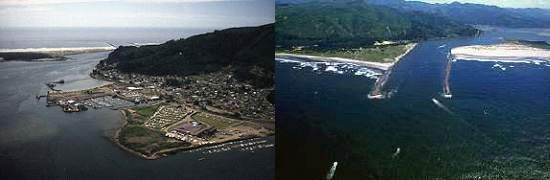
Tillamook Bay is on the Oregon coast, 50 miles south of the Columbia River.

The Army Corps of Engineers owns and maintains two jetties at Tillamook Bay’s entrance. The north jetty was constructed first in 1914 with south jetty construction beginning decades later in 1969. The Corps has made repairs to both jetties due to damage from the Pacific Ocean’s powerful waves continually smashing against them.

The north jetty was reconstructed and extended it to its full, authorized 5,700-foot length in 1931. In 2004, The Corps constructed a revetment to help prevent shoreline erosion and protect the vulnerable north jetty root. Corps contractors rebuilt the north jetty head in 2010, stabilizing the jetty at 5,213 feet. The repaired head is broader, higher and more substantial to withstand the powerful waves. The stones used for the repairs weigh between 25 to 50 tons each.

The south jetty was authorized in 1965 with completion of the first segment in 1971. The Corps completed the second segment in 1974 and the third and final segment in 1979. The 1,500-foot third segment brought the south jetty to its full authorized length of 8,000 feet.

The Corps of Engineers does not maintain recreation facilities at this location. Stay off the jetties as they are hazardous and not intended for recreational use. Nearby adjacent recreational facilities fall under the jurisdiction of private, local or state agencies. Learn more about jetties and why they are unsuitable for recreation at Understanding Coastal Jetties.

Related

Redirecting...

For more information

Oregon Coastal Harbors pamphlet

Contact us:

Phone: 503-808-4510

Email us about the Tillamook Bay

Latest News Releases

Operations: Tillamook Bay

Collapse All Expand All
 General
The Corps maintains an 18-foot-deep channel over the ocean bar at the entrance to Tillamook Bay; an 18-foot-deep, 200-foot-wide, three-mile-long channel to Miami Cove; a turning basin at Miami Cove; and a 12-foot-deep access channel to the Garibaldi small-boat basin. The Corps’ navigation authority includes protection of Bayocean Peninsula to preserve the present entrance channel to the bay. For that purpose, a 1.4-mile-long dike was constructed to close a breach in the peninsula between Pitcher Point and the abandoned town of Bayocean. The channel to Miami Cove was completed in 1927, the Bayocean dike in 1956, and the small-boat basin of Garibaldi in 1958. The 18-foot channel to Miami Cove is inactive due to a mill closure.
 Project description
Entrance:
 Channel is 5,000 feet long, 18 feet deep, and has no prescribed width.
 North Jetty is 5,213 feet long.
 South Jetty is 7,094 feet long.

From deep water in the bay to Miami Cove:
 Channel is 3 miles long, 200 feet wide, and 18 feet deep.
 Turning basin is 2,500 feet long, 500 feet wide, and 18 feet deep (currently inactive).

Garibaldi:
 Small boat basin is 12 feet deep.
 Approach and channel is 12 feet deep.

Bay Ocean Peninsula:
A sand- and rock-filled dike extends 1.4 miles between Pitcher Point and the town of Bay Ocean.
 Map
Graphic illustration map of Tillamook Bay
 Authorization
The Rivers and Harbors Acts of July 25, 1912, March 2, 1919, March 3, 1925, June 30, 1948, Sept. 3, 1954, and Oct. 27, 1965.