Building Strong® at the Nehalem River

2 aerial images of the Nehalem River Project areaNehalem Bay is located 40 miles south of the Columbia River.

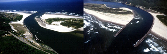
The Corps constructed two jetties to stabilize the channel across the ocean bar at Nehalem Bay's entrance. The north jetty was built in 1918, to a length of 3,890 feet; the south jetty, built in 1916, was 4,950 feet long.

The structures were rehabilitated in 1981 and 1982 after decades of strong water and wave action removed large boulders and underwater currents displaced smaller stones. Corps contractors placed more than 347,000 tons of rock at the tips of both jetties. The boulders used in the repairs weighed more than 40 tons each – at the time, the largest ever placed on an Oregon jetty.

The Corps of Engineers does not maintain recreation facilities at this location. Please stay off the jetties as they are hazardous and not intended for recreational use. Nearby and/or adjacent recreational facilities fall under the jurisdiction of private, local or state agencies. Learn more about jetties and why they are unsuitable for recreation at Understanding Coastal Jetties.

For more information

Oregon Coastal Harbors pamphlet

Contact us:

Phone: 503-808-4510

Email us about the Nehalem River

Latest News Releases

Corps of Engineers dedicates new coastal survey vessel in Newport
1/23/2023
The U.S. Army Corps of Engineers’ Portland District officially welcomed its newest hydrographic survey vessel, the Beeman, with a dedication and christening ceremony in Newport, Oregon, Jan. 11...
9,200 buckets later, Corps dredging halfway complete at Gold Beach
9/9/2022
A giant bucket – the size of a 1970s Volkswagen bus – swings through the air after it gobbles up 20 cubic yards of gravel blocking (shoaling-in) access to parts of the Port of Gold Beach, Ore. The...
Corps awards $5 million contract for Rogue River dredging at Gold Beach
3/15/2022
Army officials announce a $5.3 million contract award for dredging the Rogue River at Gold Beach, Ore. The U.S. Army Corps of Engineers (Corps) maintains navigation channels along the Oregon coast and...

Related

Redirecting...

Operations: Nehalem River

Collapse All Expand All
 Project description
Jetties:
North Jetty is 3,890 feet long.
South Jetty is 4,950 feet long.
 Map
Graphic illustration map of Nehalem River and Bay
 Authorization
The Rivers and Harbors Acts of: Sept. 19, 1890, and July 25, 1912.