Building Strong® at the Coquille River

2 aerial images of Coquille River Project area

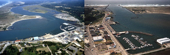
The Coquille River rises in Oregon's Coast Range and flows westerly for 100 miles, emptying into the Pacific Ocean at Bandon, Ore., 225 miles south of mouth of Columbia River and 420 miles north of San Francisco Bay.


There are two jetties at the mouth of the Coquille River. The south jetty is 2,700 feet long; the north is 3,450 feet long. There is a channel 13 feet deep from the sea to a point one mile upstream from the old Coquille River lighthouse. Project authorization also calls for removing snags from the channel up to the highway bridge at Coquille. The jetties were completed in 1908 and the entrance channel in 1933. The north jetty was rebuilt in 1942, extended in 1951, and repaired in 1956. The south jetty was repaired in 1954. Restoration of the historic Coquille lighthouse was completed in 1976.


The Port of Bandon constructed a boat basin facility in conjunction with a protective breakwater and 300-foot-long entrance channel, under Section 107 authorization in 1985.


The Corps of Engineers does not maintain recreation facilities at this location. Please stay off the jetties as they are hazardous and not intended for recreational use. Nearby and/or adjacent recreational facilities fall under the jurisdiction of private, local or state agencies. Learn more about jetties and why they are unsuitable for recreation at Understanding Coastal Jetties.

For more information

Oregon Coastal Harbors pamphlet

Contact us:

Phone: 503-808-4510

Email us about the Coquille River Project

Latest News Releases

Corps of Engineers dedicates new coastal survey vessel in Newport
1/23/2023
The U.S. Army Corps of Engineers’ Portland District officially welcomed its newest hydrographic survey vessel, the Beeman, with a dedication and christening ceremony in Newport, Oregon, Jan. 11...
9,200 buckets later, Corps dredging halfway complete at Gold Beach
9/9/2022
A giant bucket – the size of a 1970s Volkswagen bus – swings through the air after it gobbles up 20 cubic yards of gravel blocking (shoaling-in) access to parts of the Port of Gold Beach, Ore. The...
Corps awards $5 million contract for Rogue River dredging at Gold Beach
3/15/2022
Army officials announce a $5.3 million contract award for dredging the Rogue River at Gold Beach, Ore. The U.S. Army Corps of Engineers (Corps) maintains navigation channels along the Oregon coast and...

Operations: Coquille River

Collapse All Expand All
 General information
At Bandon you’ll find a privately-owned mill dock used exclusively for shipping lumber on coastwise vessels, a publicly owned wharf and a small-boat basin open to all on equal terms.
The entrance to Bandon small boat basin is 300 feet long, 100 feet wide and 13 feet deep. The access channel is 500 feet long, 50 feet wide and 13 feet deep. There is also a protective rubble mound structure.

Jetties:
North Jetty is 3,450 feet long
South Jetty is 2,700 feet long

Channel:
The navigation channel from the Pacific Ocean to river mile 1.3 is 13 feet deep.

Project authorization also calls for removing snags from the channel up to the highway bridge at Coquille.
 Map
Graphic illustration map of Coquille River
 Authorization
The Rivers and Harbors Acts of: June 14, 1880; July 13, 1892; June 25, 1910; March 2, 1919; July 3, 1930; Aug. 30, 1935, and March 2, 1945.
Section 107 project: July 14, 1960.

Related ...

Redirecting...