Why is there a higher risk of flooding after a fire?

Wildfires dramatically change the landscape and ground conditions, which can lead to a higher risk of flooding. When a wildfire burns a portion of a watershed, the resulting burn scar increases the potential for flooding until vegetation is re-established. Natural, unburned vegetation and soil normally act as a sponge during a rainfall event. However, the heat from a fire can bake the ground, creating a surface that will not absorb water and can increase the speed with which water flows off the slope. When a wildfire compromises or eliminates these normal protective functions, the potential for significant flooding and debris flows increases. The infographic illustrates this below:


Flood After Fire Infographic
Image adapted from FEMA Flood After Fire Toolkit

Two distinct types of hazards exist when a heavy rainstorm occurs on a burned watershed: flooding and debris flows.

Flash Flooding
Flash floods are a concern even without a burned watershed. The most deadly disaster in Oregon history was the flash flood in Heppner in 1903, which resulted in 247 fatalities. The odds of a flash flood increase dramatically when a fire has burned the area upstream. Destructive flash flooding occurred in 2014 near Wenatchee, Washington just a few months after the Carlton Complex fire burned the watershed upstream of the area.

 
  Water does not easily infiltrate burned soils
   
 
  2013 Flash flood in Colorado
   

For any burn area, it takes much less rainfall to result in flash flooding than before the wildfire. Even modest rainstorms or heavy rain for a short time over a burned area can cause flash flooding downstream. Thunderstorms that develop quickly over burn areas can produce flash flooding and debris flows nearly as fast as National Weather Service radar can detect the rainfall, providing only a short time for warnings. These floods are typically much larger for a given sized storm than they were before the wildfire, so flooding is likely to be much more extensive following wildfire, endangering properties previously considered safe from flooding. A general rule of thumb is that half an inch of rainfall in less than an hour is sufficient to cause flash flooding in a burn area (NOAA). Likelihood of flooding can depend on the terrain, how much time the ground has had to heal, vegetation regrowth and the severity of the fire on the landscape. These floodwaters typically transport surface debris such as downed trees and gravel, but still behave like water.

Debris Flows (Mudflows)
As water runs downhill through burned areas, it can create major erosion and pick up large amounts of ash, rocks, boulders, and burned trees, generating a debris flow (also commonly termed “mudflow”). Fast-moving, highly destructive debris flows are one of the most dangerous post-fire hazards, since they occur with little warning. High rainfall rates are the trigger for debris flows, rather than the total amount of rain. Their mass and speed make them particularly destructive. Debris flows can strip vegetation, block drainages, damage structures, and endanger human life. The force of the rushing water and debris can threaten life and property miles away from the burned area. Survivors of debris flows describe sounds of cracking, breaking, roaring, or a freight train.

Debris flows result in major devastation, as evidenced in January 2018 in Southern California and September 2014 near Wenatchee, WA. In December 2017, the Thomas fire burned many areas upslope of Montecito. Less than a month later, heavy rain on the burn scar led to severe debris flows that caused 21 fatalities and destroyed over 100 homes. In 2014, debris flows following the Carlton Complex fires resulted in severe property damage and a near-fatality.

How long do post-wildfire risks last?

In areas that have been severely burned, post-wildfire risks of floods or debris flows may last for two to five years. After two or three years, the regrowth of vegetation and reduced water repellency of the soil should lower the risk considerably.

What actions will reduce risk?

Communities cannot entirely eliminate the risk of flooding or debris flows after a fire, but they can take steps can reduce risk. Risk is a function of:

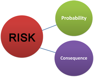
1. The probability of an event occurring
2. The negative consequences created by the event.

Strategies to mitigate risk include measures to address both components of risk. While nothing can control the weather, some measures can reduce the chances of an event on the ground. For instance, smaller culverts can clog easily with debris, which can cause water to back up and overtop roadways, potentially eroding away the slope and suddenly releasing a large amount of water. Debris control structures can be installed upstream of culverts, or they can be replaced with larger structures to reduce the chances of this situation occurring. This type of mitigation addresses the probability component of risk. Measures that mitigate the consequence component of risk include creating warning systems and purchasing flood insurance. 

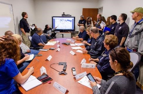
While “all disasters are local”, state and federal government agencies have a role to play in preparing for flooding hazards. When all levels of government take action, the response is more effective. Activities to respond to the post-fire threat are broken down into three categories:

1. Independent State/Federal Government Actions: Actions occur with limited community input. 
2. Direct State/Federal Government Assistance: Support potentially available by community request.
3. Community-Driven Activities: Risk mitigation activities with a more limited state/federal role.

1. Independent State/Federal Government Actions
The actions in this category will occur regardless of how proactive local communities are in asking for support. The community can inform these actions, but they will usually occur with no formal request. Some examples include:

1. Incident Management Team: State or federal agencies typically lead the direct response and firefighting activities. This team dissolves once the immediate threat of the fire is over. 
2. Burned Area Emergency Response (BAER): BAER teams identify and manage potential risks to resources on all Federal lands and reduce these threats through appropriate emergency stabilization measures to protect human life and safety, property, and critical natural or cultural resources. For more information, refer to Appendix C. 
3. Targeted forecasting: Targeted forecasting of rainfall in a burned area begins while the fire is still ongoing. The National Weather Service further refines the post-fire forecasts by reviewing values at risk and placing greater focus on watches and warnings near the burned area.

2. State/Federal Government Assistance
The community must request most assistance programs from federal and state agencies. Proactive communities ask for this support so that the burden of reducing risk is not borne entirely locally. Assistance is not always available, and different programs become available depending on the size of the fire and on what lands it occurs. For a full list of all assistance programs with eligibility requirements, refer to Oregon's Post Wildfire Playbook (2.7mb pdf).

Emergency declarations often open the door to larger state and federal assistance. Local government provides initial response to the emergency or disaster. Neighboring communities and volunteer agencies supplement these efforts. If local governments are overwhelmed, the emergency management office requests the county commissioners declare a state of emergency and request state assistance.  Once the state exceeds the amount of assistance it can provide, the Governor may make a request to the President, who may issue “major disaster” or “emergency” declarations before or after catastrophes occur. Emergency declarations trigger aid that protects property, public health and safety, and lessen or averts the threat of the incident becoming a catastrophic event. A major disaster declaration constitutes broader authority of federal agencies to provide supplemental assistance to help state and local governments, families and individuals, and certain nonprofit organizations recover from the incident.

State and federal assistance takes two general forms: direct services and financial grants. Direct services are those actions for which the agencies do the work themselves, with no transfer of funds to the community. Other assistance programs use a more grant-based approach that transfer financial resources to the community for them to manage. Grant funding is often uncertain: financial limitations, benefit-cost requirements, and competition sometimes prevent award of grants. The table below gives some examples of direct services and financial grants—see Oregon's Post Wildfire Playbook (2.7mb pdf) for a full list:

Direct Services Financial Grants
Rapid-deployment rain gauges Emergency Watershed Protection Program
Flood and debris flow risk assessments Hazard Mitigation Grant Program
Emergency Permitting Technical Assistance Grant
  Environmental Quality Incentive Program (e.g. reseeding)


3. Community-Driven Activities
State and Federal assistance will not cover all the needs of a community. While state and federal agencies support risk mitigation activities, many actions require a stronger local lead. Local governments are better suited to lead many activities, since they know the area and population much better than state and federal officials. Local governments should work with private landowners and soil and water conservation districts to accomplish these risk reduction measures. Some activities that the local community typically leads include:

1. Risk communication to residents and landowners: While state and federal agencies may hold occasional public meetings and emphasize risks via their public information offices, the most trusted voices to residents are local government agencies. Residents and businesses in areas downstream of a wildfire should be aware of the hazards they face, the steps they can take to reduce their risk, and resources that may be available to assist them. Ensuring that the community is well-informed and prepared for risks will help the community be more resilient if a flood occurs. At a minimum, residents should be encouraged to sign up for emergency alert services.

2. Flood insurance. Local governments can encourage residents to purchase flood insurance policies. Homeowner’s insurance does not cover flooding. Homeowners must purchase separate policies to cover flood damage through the National Flood Insurance Program or from private insurers. Floods after wildfire are typically more extensive than before wildfires. Individuals and businesses downstream of the burned area need to reassess their flood risk and re-evaluate the need to purchase flood insurance even if they were previously outside the flood zone. There is normally a 30-day waiting period for new flood insurance policies to go into effect. FEMA may waive this requirement if a property is affected by flooding on burned federal land and the policy is purchased within 60 days of the fire containment date. To find out more about flood insurance, contact the Oregon Department of Land Conservation and Development or go to FEMA’s webpage

3. Flood warning systems. One option to reduce risk is to install a flood warning system with sirens or other warning cues. While the National Weather Service may be able to assist in alert thresholds, it is up to the local government to operate the system.

Why coordinate after a fire?

In any large-scale event, it is critical to establish a framework for coordination among all parties involved in the response. Unlike during the fire, a federal or state unified incident command does not generally manage response or recovery after a fire. Instead, each agency and each level of government continues to act on its own authority. This creates an even greater need for coordination at the local level and sharing information among agencies to coordinate wildfire recovery efforts. 

Who should lead the response effort?

Typically, the community establishes a locally-led post-fire coordination group to lead and direct the response to the wildfire and any subsequent natural hazards, and help determine post-fire treatment options. The local emergency management office is usually best suited to coordinate this group. State and federal partners contribute to the team, but it is more important to ensure that local groups are part of the team. Particularly key partners are the local Soil and Water Conservation Districts (SWCDs), as they provide a link to private landowners who will be directly affected by the increased hazard. If local emergency management is not staffed to lead the response, SWCDs can often fill the gap. The primary functions of the group include:

• Coordinating the risk assessment and the exchange of information among agencies and landowners
• Assembling and exchanging geospatial data
• Matching risks to the agency best able to mitigate the risk
• Supporting public communications
• Coordinating with elected officials

The flood and debris flow risks typically comprise just one component of the larger team. Often, sub-teams address specific hazards or risk communication. For an example of how this occurred in the Eagle Creek fire, refer to Appendix A. 

How does post-fire response to the flood hazard come together?

There is no one-size-fits-all approach to addressing the post-fire risk. It differs based on the location, scale of destruction, and the land owners of the burned areas. After establishing a coordination team to address the risk of flooding and debris flows, some best practices apply. The figure below gives a helpful framework for thinking about responses after the fire. This process should begin before the fire is completely contained. While the figure shows a linear process, it is likely that additional risks will emerge through the course of the post-fire response.

Phase 1-Assess Risks
Before beginning a concerted response effort, the coordination team should assess the severity of the risks. The coordination team should begin by sharing all known analysis on flood risk that existed before the fire. Potential steps to take in this phase include:
1. Retrieve existing information. This typically includes retrieving FEMA floodplain maps, hydraulic models of the rivers and creeks in the area, rainfall-runoff models, the BAER team reports and maps, and any other relevant existing work. 
2. Conduct a field visit. This should involve all agencies participating in the coordination to see the areas of the community at risk. This field visit does not need to involve traveling inside the fire perimeter, but should include areas at risk downstream or downslope of the fire. 
3. Establish a risk register. A working database of risks identified and potential mitigation measures is critical to a coordinated effort. 
4. Connect private landowners with support. This includes ODF Stewardship foresters, NRCS District Conservationist, or Soil and Water Conservation Districts that can assist with replanting efforts and erosion management. The Emergency Watershed Protection Program is one resource for private lands to assist with streambank protection, debris clearing from channels, and other protective measures. 
5. Apply for advance measures from USACE. If the risk is severe enough and the emergency has depleted local and state resources, USACE may be able to provide support in risk assessments through the Advance Measures program.

Phase 2-Establish Monitoring
Monitoring activities provide no reduction in probability of an event occurring, but they can give advanced warning of hazards. Monitoring provides a mechanism for the coordination team to stay up-to-date with the situation on the ground and adapt to an evolving risk landscape. Potential activities include:

 
  Rain gauging station
   

1. Request a rapid-deployment stream gauge from OWRD or USGS
2. Request a rapid-deployment rain gauge from NWS
3. Work with NWS, USGS, and USACE to set up emergency alert thresholds based on rainfall rates.
4. Contact NRCS to see if targeted snowpack forecasting is available
5. Visit the creeks in the area periodically to document changes in channel conditions (e.g. sedimentation and debris).

Phase 3-Mitigate short-term risks
After identifying a significant risk, the team should explore options for mitigation of that risk. Short-term risks are defined here as those that can be addressed within 3 months of the fire. Many of the mitigation measures in this phase are temporary, just to get the community through the winter. Potential mitigation measures for risks include:

1. Coordinate emergency response preparation. This could involve developing an Incident Action Plan to respond to a flood/debris flow.
2. Procure a source for sandbags and Hesco barriers and notify residents of distribution procedures so they can protect their property. 
3. Elevate critical equipment and records that may be lost if a flood occurs. 
4. Install debris control structures upstream of culverts.
5. Construct temporary berms to reduce risk of flooding, with proper permits.
6. Clear debris and downed trees from the channel (without excavation of the creek bed).

Phase 4-Mitigate long-term risks
Risks from fire can last several years, and short-term solutions are only a temporary fix to the problem. There often exists an opportunity to reduce risk in the long-term after the fire. The actions in this section generally take more time to coordinate, but result in more significant risk reduction. Potential mitigation activities include:
1. Apply for mitigation projects through OEM using Hazard Mitigation Grant funds, if applicable. Mitigation projects can be very diverse, but can include buyouts of especially risky properties, replacing or relocating vulnerable infrastructure, restoring the landscape post-fire, and installing a flood warning system. 
2. Apply for a Technical Assistance Grant from DLCD if the community natural hazard mitigation plan needs an update.
3. Apply for a flood risk reduction study from USACE. This can take the form of a planning study only, or a small flood risk management construction project managed by USACE. 
4. Replace undersized culverts with larger structures (culverts or bridges)

What community officials and residents should know

Maintaining a steady flow of communication is critical to ensure that residents do not forget the continuing risk after the fire is over. FEMA has developed an extensive media toolset to assist with communications on flood risk that occurs after fire. The Flood After Fire toolkit contains templates for social media posts, infographics, and ideas for press releases. The toolkit is free of charge, and a link is in Appendix D. Appendix E offers a compilation of other suggested language for social media posts. Below are some tips to assist individuals, families, and businesses at this difficult time.

Document, document, document: Take pictures of your property from multiple angles (and provide “before” images if they are available). Taking pictures is one of the most important things you can do to help yourself.

Keep all of your receipts from restoration and recovery projects.

Consider purchasing flood insurance: A top priority after a wildfire is flood preparedness; flood insurance reduces financial exposure to flood damages. To find out more about flood insurance, contact the Oregon Department of Land Conservation and Development or go to FEMA’s informational webpage on how to buy flood insurance.

Do not assume FEMA is all you need. A Presidential Disaster Declaration is required for a community to become eligible for FEMA funding. FEMA assistance, when provided, provides minimum assistance to get people on their feet after a disaster.

Who made this guide?

The Oregon Silver Jackets team is a partnership of state and federal agencies with a role in assessing and managing flood risk across the state. The Oregon Silver Jackets created this guide to increase preparedness for flooding and debris flow concerns after wildfires and provide a singular picture of state and federal assistance, rather than reaching out to each agency individually. Primary authors to this guide included: Angie Lane (OEM), Nick Henneman (ODF), David Lentzner (DLCD), Cara Farr (USFS), Spencer Higginson (NWS), Ryan Cahill (USACE), and Marc Stewart (USGS). For more information, visit the Oregon Silver Jackets website.